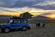
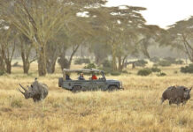
Noel, Maggie and I lived in Botswana from 2010-2012, so it’s a country that holds a very special place in our hearts.
As one of the least populated countries in Africa (second only to Namibia), Botswana is full of vast, unspoilt wilderness, from the Central Kalahari Game Reserve (the second largest in the world) to the Okavango Delta (the world’s largest inland delta)!
If this weren’t enough, the country is also one of the most peaceful, stable and prosperous in sub-Saharan Africa. So for those safety-conscious travellers who may be hesitant about African overlanding, Botswana is an excellent place to get your feet wet.
Many of Botswana’s best places to visit are remote and difficult to reach by public transportation – precisely why the country is a joy to overland.
We’ve travelled extensively throughout Botswana and have experienced most of what the country has to offer. The ‘usual’ tourist trails nearly always include Chobe and Moremi National Parks in the north, in addition to Khutse and the Central Kalahari Game Reserve.
Some campsite booking can be still done on the cheap through the Department of Wildlife and National Parks. However, in recent years, campsites have been (rather annoyingly) given out to private tour companies, which book up quickly, often charge high fees and provide little-to-no benefit to local communities.
Based on our experience, here are our favourite destinations off of the ‘normal’ tourist trail, which may also benefit local communities.
Kubu Island and the Makgadigadi Pans
Coordinates: -20.895274, 25.809494 (20°53’43.0″S, 25°48’34.2″E)
Our all-time favourite place in Botswana, and maybe even Africa, Kubu Island can only be described as magical. The indigenous rock island full of baobab trees juts out of the flat, moon-like surface of the Sua (Sowa) pan, one of the many salt pans that make up the Makgadikgadi.
The site is managed by a community trust and offers several campsites, which promise a peaceful and serene stay, as long as you avoid going on the weekends when tours are often organised from Gaborone. Ablution facilities (a southern African word for toilets and showers) are also limited, but what it lacks in ablution it certainly makes up for in stunning landscape.
Our tips to get the most out of Kubu: Wake up early and trek to the eastern-most ledge of the island to watch the sun rise over the flat and serene landscape. The drives north from Kubu to Nata and to Maun offer breathtaking views of the pans, but don’t be afraid to ask local for directions and bring your GPS just in case (the roads are not always well marked).
Tuli Block (Northern Tuli Game Reserve)
Coordinates: -22.499427, 28.770970 (22°29’57.9″S 28°46’15.5″E)
Definitely the most underrated of Botswana’s parks, the ‘Tuli Block’ – also called the Northern Tuli Game Reserve – is a thin strip of land in Botswana’s eastern-most corner, on the Limpopo river bordering Zimbabwe and South Africa.
Perhaps because the private game farms of the Tuli Block are expensive and only reachable by over 30km of corrugated, dirt roads, we found it secluded, peaceful and stunningly beautiful. And much more affordable when using campsites, rather than luxury lodges.
Imagine camping on the banks of the Limpopo river, sun setting as you watch a herd of hippos swim up and down the river… paradise!
We stayed at the simple, yet beautiful campsites of the Limpopo River Lodge (pictured above), which sit right on the river and happened to be completely unoccupied! What luck 
Dqãe Qare Game Farm (San Lodge)
Coordinates: -21.635200, 21.818317 (21°38’06.8″S, 21°49’05.5″E)
For those who are looking to spend some quality time with local communities, or simply for a more sustainable alternative to the for-profit campsites in the CKGR, we recommend the Dqãe Qare Game Farm.
In this authentic reserve run by the local San (Bushmen) community, you can opt to stay in traditional round huts or campsites. Activities such as guided bushwalks and traditional dancing can also be arranged, with proceeds going to support the local indigenous community.
If visiting in August, you can also seize the opportunity to attend the Kuru Dance Festival – a time when San communities from all over southern Africa descend on the game farm for a weekend of traditional dancing and celebration of indigenous culture.
The site is 15km south of D’kar, and only accessible by 4WD vehicle, making it a perfect stop for overlanders looking for a memorable experience!
When moving on, don’t forget to visit the Kuru Art Project in nearby D’kar to pick up some traditional San artwork!
Elephant Sands
Coordinates: -19.749612, 26.071365 (19°44’58.6″S, 26°04’16.9″E)
Imagine camping on pristine, white sandy beaches in the bush, with plenty of elephants and a fully stocked bar.
If that sounds appealing to you, you’re guaranteed to love Elephant Sands, a bush lodge and campsite, located 52km north of Nata on the road to Kasane.
The site offers 10 en-suite chalets, a lodge as well as a campsite. It is located on a private, unfenced conservancy of 16,000 hectares, where wildlife – including many elephants! – roam freely through and around the premises.
The site is difficult to reach without a private vehicle, making it an excellent stop on the way to or from Kasane and the Chobe National Park.
We ended up staying there a few nights because the place was so magical it would have been rude to leave after only one night! And if you visit in winter, the campsite had it’s own supply of wood, so our campfire was always roasting hot during the cold wintery nights!
Khama Rhino Sanctuary
Coordinates: -22.234676, 26.719866 (22°14’04.8″S 26°43’11.5″E)
About 25 km north of Sorowe on the road to Orapa lies the Khama Rhino Sanctuary, a 8,500 hectare community-based wildlife project dedicated to protecting and conserving endangered white and black rhinos in Botswana.
With a population of 30 white and 4 black rhinos, you’re almost guaranteed to spot a few, especially at the many water holes. In addition to Rhinos, the sanctuary boasts many other animals, including giraffe, ostriches, hyenas and leopards.
The 22 campsites run by the Rhino Sanctuary Trust at the sanctuary are shady and well-maintained (pictured above), but there are also a number of four and six person chalets which are reasonably priced.
The sanctuary and campsites are easily accessible to the main road, but much more fun to explore with a 4WD! It’s a great place to visit either during a weekend away from Gaborone (only 3-4 hours drive), or on the way to Kubu Island and the Makgadikgadi pans.
Mbiroba Camp and the Okavango Poler’s Trust
Coordinates: -18.826244, 22.432710 (18°49’34.5″S 22°25’57.8″E)
Deep in the Okavango Delta, approximately 100km from Shakawe, is the Okavango Poler’s Trust, established in 1998 as an eco-tourism business for the benefit of the local community in Seronga. Mokoro safaris run by the Trust are a cheaper and more authentic alternative to those run by the easier-to-access and tourist-filled Maun lodges. Because they are cheaper, however, they are also self-catering, so participants need to be relatively self-sufficient.
But the best part is that, because the Trust is run by the village, all of the profits go to benefit the local community. The Trust currently employs over 100 people, including polers, caterers, traditional dancers and singers.
Campsites and chalets are available at the Mbiroba Camp, also run by the Trust, and offer ablution facilities and a bar (hooray!). The camp is only accessible with a 4×4 vehicle, making it a perfectly secluded destination for overlanders.
Khwai Development Trust and the Okavango Delta

Bridge over the river Khwai (ha!), leading to Khwai Development Trust, courtesy of flikr user Di Gazdar
Coordinates: -19.126823, 23.659348 (19°07’36.6″S 23°39’33.6″E)
Get back to basics at the Magotho Camp run by the Khwai community, in the Okavango Delta near the border of popular Moremi National Park. Although not nearly as luxurious as sites found inside Moremi or Chobe National Parks, but priced about the same (P300/per person/per night), the profits from this campsite go directly to community development projects.
The camp is little more than an open space along the river, offering no ablution facilities or provisions, and is infested with hyenas and other wild animals. Some people love the simplicity and dangerous proximity to wildlife, but others hate it! So be warned, or get excited, depending on your appetite for adventure 
One thing is for sure – this is the only campsite open to the public in the Delta (that we know of) that directly supports the community indigenous to the area, the Khwai (or ‘River Bushmen’).
Other private camps in Moremi claim to have a sustainable impact, but offer little more than meagrely-paid jobs to educated Batswana from Maun or other points south, in our experience.
At the time of writing, the Khwai Development Trust did not have a website or online booking system, but can be contacted at: +267 6801211 or khwai@botsnet.bw. Bookings must be made in advance.
Sankuyo Tshwarangano Management Trust
Coordinates: -19.590058, 23.803425 (19°35’24.2″S 23°48’12.3″E)
If Magotho Camp sounds too rough and ready, the Sankuyo Tshwaragano Management Trust could be a more comfortable alternative.
About 65km north of Maun, on the way to Moremi / Chobe National Parks, the Trust has developed a campsite (Kazikini), traditional village (Shandereka Cultural Village) and lodge (Santawani Lodge). Profits from these undertakings are for the benefit of nearby Sankuyo village.
In easy distance to Moremi National Park (26km to the South Gate), the Trust offers some authentic and reasonably priced alternatives to privately-operated lodges and sites. Visitors can also enjoy nature walks, game drives, mokoro trips, and cultural tours. Campsites also boast ablution facilities and a restaurant / bar.
Nata Bird Sanctuary
Coordinates: -20.288384, 26.300986 (20°17’18.2″S 26°18’03.5″E)
Just 18km south of Nata along the road from Francistown to Maun/Kasane, in the northeast corner of the Sua (Sowa) pan, lies the Nata Bird Sanctuary, a community-run protected reserve that is home to 165 species of bird, as well as other wildlife.
The Sanctuary is an excellent spot for nature walks and bird watching, as well as camping – there as several campsites near the entrance. Although we found the reserve stunning, especially at sunset, the campsites do sit adjacent to the road, which makes for a less-than-serene atmosphere.
Nevertheless, we recommend a visit, especially as a stop over to Maun or Kasane!
Mokolodi Nature Reserve
Coordinates: -24.739572, 25.818032 (24°44’22.5″S 25°49’04.9″E)
For those passing through, or looking to get out of, Gaborone, the Mokolodi Game Reserve is a must-see destination located just 20km south of the capital city.
It’s a 12,500 private reserve, that offers a number of tourist activities – including game drives, animal tracking, horseback safaris and cheetah petting – to support its conservation and education programmes.
The Reserve offers shaded and private campsites, as well as rather luxurious chalets. Sun downers at the Mokolodi Tea Garden are also highly recommended!
